Sandakphu's Lepcha name is usually translated as the height of the poisonous plant, after Aconitum ferox and toxic rhododendrons. Drovers once had to muzzle sheep and cattle passing through to stop them grazing.
Source: Sandakphu
Himalaya only · Saver trips from ₹7,500
Try "Spiti", "snow leopard", "Char Dham", "homestay", "Tiger's Nest"
National park in Darjeeling & Kalimpong
West Bengal's highest point, with Everest on the skyline
Sandakphu, at 3,636 m on the Singalila Ridge, is the highest point in West Bengal. From the summit village you see Everest, Lhotse, Makalu and the Kangchenjunga range. Walk up from Manebhanjan in 3–4 days with a compulsory guide, or ride a vintage Land Rover. October–November and March–May are best.
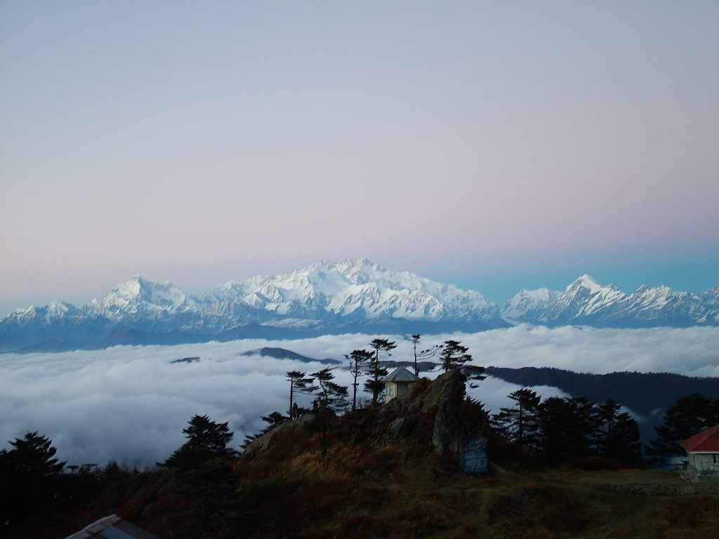 Photo: solarshakti · CC BY 2.0 · Commons
The Singalila Ridge runs north from the Darjeeling hills along the India–Nepal border towards Sikkim. Its highest point, Sandakphu, rises to 3,636 m, with a small summit village of lodges, trekkers' huts and a few houses. From there the skyline holds four of the five highest mountains on Earth: Everest, Lhotse and Makalu to the west, and the long wall of Kangchenjunga to the north, which locals call the Sleeping Buddha for its outline.
Most of the ridge lies inside Singalila National Park, declared a sanctuary in 1986 and a national park in 1992. Its forests of oak, magnolia, bamboo and rhododendron shelter red pandas, which have been reintroduced here, as well as black bears and more than 120 bird species. The name Sandakphu comes from Lepcha and is usually translated as the height of the poisonous plant, after the aconite that once grew thickly here.
You can walk or ride. The classic trek starts at Manebhanjan, 28 km from Darjeeling, and climbs through Tumling and Kalipokhri over three or four days, often continuing to Phalut, 21 km further. Or ride one of the old Land Rovers that still carry passengers up the ridge road. Either way, nights above 3,000 m need care: acclimatise, keep warm and talk to your doctor if you have heart or lung conditions.
From Sandakphu the Kangchenjunga range lies across the northern horizon in a shape locals call the Sleeping Buddha. At sunrise its summits turn pink one by one. Everest, Lhotse and Makalu stand to the west on clear mornings, mostly October to December.
The trail from Manebhanjan to Sandakphu runs through forest and along open ridge, crossing between India and Nepal several times. Stages are short, 4–6 hours a day, but the climb is steady. Trekkers' huts and lodges provide beds and simple food.
A community fleet of old Land Rovers carries passengers from Manebhanjan to Tumling, Sandakphu and Phalut. The ride is rough, slow and memorable. It suits travellers who want the views without walking.
From March to May, rhododendrons flower across the ridge between about 2,000 and 3,600 m. A second bloom of primulas, geraniums and orchids follows the monsoon in October. Spring haze can hide the peaks; autumn is clearer.
Phalut, at about 3,600 m, is West Bengal's second-highest peak, 21 km north of Sandakphu. The walk there along the open ridge is quieter and gives a closer view of the Kangchenjunga range. Descend via Gorkhey and Srikhola to Rimbik.
Field notes
Sandakphu's Lepcha name is usually translated as the height of the poisonous plant, after Aconitum ferox and toxic rhododendrons. Drovers once had to muzzle sheep and cattle passing through to stop them grazing.
Source: Sandakphu
Singalila was declared a wildlife sanctuary in 1986 and a national park in 1992. In 2004 two captive-bred red pandas from the Darjeeling zoo were released here; one, Sweety, adapted and gave birth in the wild.
Source: Singalila National Park
The first documented attempt to climb Kangchenjunga, in 1905, led by Jules Jacot-Guillarmod with Aleister Crowley, approached along the Singalila Ridge.
Source: Singalila National Park
Experiences
 Photo: Alexkom000 · CC BY 4.0 · Commons
Wake before dawn on Sandakphu, the highest point in West Bengal, and watch first light reach Kangchenjunga's Sleeping B…
 Photo: Dreamplexx · CC BY-SA 4.0 · Commons
Ride from Manebhanjan to Sandakphu in one of the vintage Land Rovers that still serve the ridge road, crossing between …
 Photo: Shilbhadra · CC BY-SA 3.0 · Commons
Walk 21 km north along the open Singalila Ridge from Sandakphu to Phalut, at about 3,600 m the second-highest peak in W…
Real prices
Local prices change with season and fuel costs. Check current status before you travel.
Getting there
Air
Fly to Bagdogra, then drive about 100 km via Darjeeling or Mirik to Manebhanjan, the trailhead, in about 4 hours.
Rail
Take a train to NJP, then a shared jeep to Darjeeling and on to Manebhanjan. Most trekkers spend the first night in Darjeeling.
Road
Shared jeeps run from Darjeeling to Manebhanjan, 28 km and 1–1.5 hours, for about ₹80–150. From Manebhanjan, Land Rovers drive the ridge road to Tumling, Sandakphu and Phalut. Snow can close the road briefly in winter; check current status before you travel.
Where to stay
Everyone on the ridge stays simply. Saver and comfort trekkers sleep in government trekkers' huts and private lodges at Tumling, Kalipokhri, Sandakphu and Phalut, in dormitories at about ₹300–600 a bed or basic private rooms at ₹800–1,500 per person, often with shared toilets and no heating. Book ahead in October–November. Signature travellers get the best room available, a private guide and porter, and a heritage hotel in Darjeeling before and after; there is no luxury lodge on the ridge.
Trips that stop here
 Photo: Arne Hückelheim 2010-09-21 12:41:53 This is a … · CC BY-SA 4.0 · Commons
Signature
Photo: Arne Hückelheim 2010-09-21 12:41:53 This is a … · CC BY-SA 4.0 · Commons
Signature
Private SUV with driver; reserved Land Rover on the Singalila Ridge
Questions
Plan 5 to 7 days from Darjeeling. The walk from Manebhanjan to Sandakphu takes 3–4 days via Tumling and Kalipokhri. Adding Phalut and the descent via Gorkhey and Srikhola to Rimbik takes 2–3 more. By Land Rover, Sandakphu can be done in 2 days, but a night at Tumling first is wiser.
Yes. Singalila National Park requires trekkers to hire a registered guide at Manebhanjan. Guide fees are about ₹1,000–1,500 a day for a small group, and guides arrange lodges. Rules change, so check current status before you travel.
A saver trek for 4–5 days costs about ₹12,000–18,000 per person, sharing a guide, staying in trekkers' huts and eating local meals. Adding a porter, private rooms or Land Rover legs raises costs. Figures are indicative 2026 and exclude travel to Darjeeling.
You might. Sandakphu is 3,636 m and you sleep above 3,000 m. Climb gradually, spend a night around 2,900–3,000 m first, drink water, avoid alcohol, and tell your guide about headaches or nausea. Descend if symptoms worsen. Talk to your doctor before trekking if you have health conditions.
October and November give the clearest views and dry trails. March to May brings rhododendrons but more haze. December to February is very cold with possible snow, and the road can close briefly. The park and trail are effectively off-season from June to September.
The trail crosses into Nepal at points such as Tumling and Kalipokhri. Indian citizens should carry a government photo ID; foreigners must carry passport and Indian visa for checkposts. Entering Nepal beyond the ridge needs normal immigration. Check current status before you travel.
Signal is patchy. Some spots pick up Indian networks, others only Nepali ones, and Sandakphu has limited coverage. Do not rely on mobile payments or maps; carry cash and a downloaded map, and tell family you may be offline.
Yes, fit beginners often do it. Daily stages are 4–6 hours, trails are clear, and lodges remove the need for tents. Prepare by walking hills for a few weeks, carry a light pack, and hire a porter if needed. The challenge is altitude and cold, not technical difficulty.
Many women trek it alone or in small groups. A registered guide is compulsory anyway, and lodges are shared and sociable. Choose a guide through the official association at Manebhanjan or a known operator, share your itinerary, and keep emergency contacts handy.
Plan with a local planner
We reply within one working day with a route, a sleeping-altitude profile and an itemised price in your tier. Change anything. Pay nothing until you are sure.